
Lower Mustang Trek – 10 Days
Destination:
Lower Mustang Region
Trip Duration:
10 Days / 9 Nights
Max Altitude:
3,800 m (Muktinath)
Activities:
Trekking, Cultural Sightseeing, Temple & Monastery Visits, Hot Spring Bathing
Start Point:
Kathmandu
Ending Point:
Kathmandu
Region:
Annapurna Conservation Area, Lower Mustang (Kali Gandaki Valley)
Trip Grade:
Moderate
Group Size:
2–12 People (Private/Customized Groups on Request)
Accomodation:
3-Star Hotels in Kathmandu & Pokhara; Teahouses/Lodges During the Trek
Meals:
Full Board (Breakfast, Lunch, Dinner) During the Trek; Breakfast Only in Kathmandu/Pokhara
Transportation:
Private Vehicle / Tourist Bus (Kathmandu–Pokhara), Domestic Flight (Pokhara–Jomsom–Pokhara)
Permits Required:
ACAP (Annapurna Conservation Area Permit) & TIMS Card
Best Season:
March–May (Spring) & September–November (Autumn)
Lower Mustang Trek: A Complete Guide to Nepal’s Hidden High-Desert Kingdom
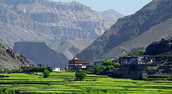
The Lower Mustang Trek is one of the few Himalayan journeys where the landscape itself feels like the destination. Tucked behind the rain shadow of the Annapurna and Dhaulagiri massifs, this region trades Nepal’s familiar green hillsides for wind-carved cliffs, ochre-colored canyons, and villages that look more like Tibet than the Kathmandu Valley. For travelers searching for a trek that blends dramatic geography with deep cultural immersion — without the permit costs or remoteness of Upper Mustang — the Lower Mustang Trek consistently ranks as one of the most rewarding short treks in the country.
Why the Lower Mustang Trek Stands Apart
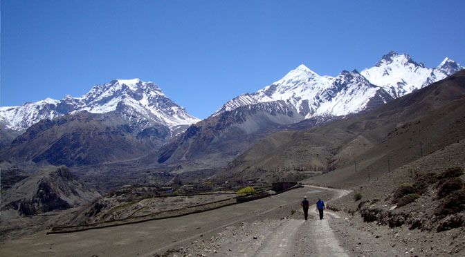
Most Himalayan treks push trekkers toward glacier basins or high mountain passes. The Lower Mustang Trek does something different: it follows the Kali Gandaki River through the deepest gorge on Earth, a geological corridor squeezed between two 8,000-meter giants. This positioning gives the region its defining feature — a rain-shadow climate that produces a stark, desert-like terrain unlike anywhere else on Nepal’s standard trekking circuit
. Sun-bleached cliffs, wind-sculpted rock formations, and centuries-old cave dwellings carved directly into canyon walls define much of the scenery, making this Jomsom Muktinath trek route feel closer to the high plateaus of Tibet than to the forested trails most visitors expect from Nepal.
A Trek Rooted in Trade History and Living Culture
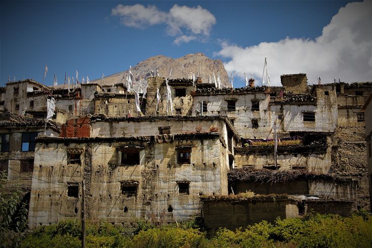
Long before it became a trekking destination, this corridor functioned as a vital salt-trade route linking Tibet with the Indian plains. Mule caravans once moved through villages like Kagbeni, Tukuche, and Marpha, carrying salt, wool, and grain across the Himalaya. That trading legacy is still visible today in the architecture: flat-roofed stone houses stacked with firewood, narrow covered alleyways built to block the valley’s fierce afternoon winds, and centuries-old monasteries that anchor community life in almost every village along the trail.
The people of this region — predominantly Thakali, with Tibetan and Gurung communities woven throughout — have preserved a cultural identity shaped by Tibetan Buddhism, even as the rest of Nepal shifted toward other traditions. Walking through Kagbeni or Jharkot, it’s common to hear monastery chants at dawn, pass elderly residents spinning hand-held prayer wheels, and see mani walls and chortens marking the entrance to nearly every settlement. This cultural depth is part of why so many trekkers describe the Lower Mustang Trek as feeling more like a journey through a living museum than a conventional hiking route.
Geography and Terrain Along the Route
The trek’s terrain shifts dramatically over a relatively short distance, which is part of its appeal. Trekkers typically begin in the greener, forested lower reaches near Pokhara, then fly or drive into Jomsom, where the landscape opens into wide gravel riverbeds and barren desert ridgelines. Moving further north toward Kagbeni and Muktinath, the scenery becomes progressively starker, with sparse vegetation, towering canyon walls, and views that stretch toward the Tibetan plateau.
On the return leg, the trail drops back through pine forest, rhododendron groves, and eventually the humid, waterfall-lined lower valley near Tatopani — a transition that showcases an unusually wide range of Himalayan ecosystems within a single trek.
This geographic diversity is one of the main reasons a well-planned Lower Mustang Trek itinerary is worth following closely rather than rushing. Moving too quickly through the upper sections not only limits acclimatization but skips past some of the most visually striking terrain transitions in the entire Annapurna region.
Who the Lower Mustang Trek Is Suited For
Because the trek’s highest point sits under 3,800 meters and elevation gain is gradual, it’s often recommended for first-time Himalayan trekkers, families with older children, and travelers with limited trekking experience but reasonable fitness. At the same time, experienced trekkers are drawn to the route for its cultural depth and the chance to explore villages that see considerably fewer visitors than the main Everest or Annapurna Base Camp trails.
This dual appeal — approachable for newcomers, rewarding for veterans — is part of what keeps the Lower Mustang Trek among the more consistently recommended treks for travelers researching a Lower Mustang Trek itinerary day by day before booking.
Understanding the Best Time for Lower Mustang Trek
Timing plays a bigger role here than on most Nepal treks, largely because of the region’s rain-shadow position. The best time for Lower Mustang trek departures generally falls in spring (March to May) and autumn (September to November), when skies are clearest and mountain views are least likely to be obscured by cloud cover. What sets Lower Mustang apart from most Himalayan routes, however, is that it remains trekkable even during the summer monsoon, since the surrounding peaks block most of the rainfall that affects other regions of Nepal.
This makes it one of the few treks worth considering for travelers whose only available window falls between June and August, when most other Himalayan trails become muddy, leech-prone, or socked in with cloud.
Winter (December to February) is also possible, though colder night temperatures at higher points like Muktinath call for more careful gear preparation.
Trekking Similar to Tilicho Lake & Lower Mustang Trek
- Annapurna Circuit Trek: 15 Night – 16 Days
- Manaslu Circuit trek-14N/15D
- Everest Base Camp Trek- 12 Days/ 11 Night
Nepal Pilgrimage & Cultural Tours
- Buddhist Pilgrimage Tour 6 Nights / 7 Days
- Kathmandu, Pokhara & Muktinath 7 Nights / 8 Days
- 8 Days Culture, Wildlife & Heritage of Nepal
- Mani Rimdu Festival in Everest Region 11 Nights / 12 Days
- 1-Day Kathmandu UNESCO Heritage Tour with Complimentary Nagarkot Sunrise & Rani Jhula
Planning a Lower Mustang Trek Around Your Travel Goals
Because the route can be adjusted in length, starting point, and pace, many trekkers customize their Lower Mustang Trek itinerary based on available time, fitness level, and whether they want to combine the route with the wider Annapurna Circuit. Trekkers with limited time often focus on the core Jomsom–Kagbeni–Muktinath stretch, while those with more flexibility extend the route south through Marpha, Lete, and Tatopani for a fuller experience of the valley’s changing landscapes.
For official permit information and updated regulations, the Nepal Tourism Board and the Annapurna Conservation Area Project are the most reliable sources to consult before departure, since permit rules and fees are periodically revised.
Lower Mustang Trek – 10 Days Highlights
- Fly through the world's deepest gorge between Dhaulagiri (8,167m) and Annapurna I (8,091m) en route to Jomsom
- Explore Kagbeni, a medieval walled village marking the gateway to Upper Mustang
- Visit Muktinath Temple, a sacred pilgrimage site for Hindus and Buddhists with its 108 water spouts and eternal natural flame
- Walk through Marpha, Nepal's cleanest village, known for apple orchards, brandy distilleries, and flagstone lanes
- Trace the historic Kali Gandaki trade route through Tukuche, once a key salt-trading post between Tibet and India
- Experience dramatic landscape shifts — from lush Annapurna foothills to high-altitude Mustang desert and back to subtropical forest
- Soak in the natural hot springs of Tatopani after days on the trail
- Take in close-up views of Dhaulagiri and Annapurna massifs from Kalopani and Lete
- Immerse in Kathmandu's UNESCO World Heritage Sites — Pashupatinath, Boudhanath, and Swayambhunath
- Discover centuries-old Buddhist gompas and traditional Thakali culture throughout the Mustang villages
Lower Mustang Trek Route Details
The Lower Mustang Trek follows the Kali Gandaki valley, the world’s deepest gorge, carved between the towering massifs of Dhaulagiri and Annapurna. The route begins with a short mountain flight from Pokhara to Jomsom, after which the trail follows the windswept riverbed north to Kagbeni, a walled medieval village marking the threshold of Upper Mustang.
From there, the path climbs steadily out of the valley to Muktinath at 3,800 meters, the trek’s highest point and one of the most sacred pilgrimage sites in the Himalaya, before descending back through Jomsom toward the apple-orchard village of Marpha.
South of Marpha, the trail retraces the Kali Gandaki downstream through Tukuche and Kalopani, where the stark high-desert terrain of Mustang gradually gives way to pine forest and closer views of Dhaulagiri and Annapurna. The descent continues through Lete and into the increasingly lush, subtropical lower valley, ending at Tatopani, known for its riverside hot springs.
Altitude, walking distance, and trekking duration vary considerably along the route, from short transitional days near Jomsom to longer descents of six to seven hours approaching Tatopani, so the itinerary is paced to allow for both scenic exploration and comfortable acclimatizan.
Include
- Airport pick-up and drop-off by private vehicle
- 3 nights hotel accommodation in Kathmandu (B&B basis)
- 1 night hotel accommodation in Pokhara (B&B basis)
- All teahouse/lodge accommodation during the trek
- All meals (breakfast, lunch, dinner) during the trek with tea/coffee
- Kathmandu–Pokhara and Pokhara–Jomsom–Pokhara flights
- ACAP (Annapurna Conservation Area Permit)
- TIMS (Trekkers' Information Management System) card
- Licensed, experienced English-speaking trekking guide
- Porter service (1 porter for every 2 trekkers, 15 kg limit per client
- Guide and porter salary, insurance, food, and accommodation
- First-aid medical kit carried by the guide
- Kathmandu sightseeing tour with private vehicle and guide (Day 2)
- All government and local taxes
- Welcome and farewell dinner
Exclude
- Nepal entry visa fee
- International airfare to/from Kathmandu
- Travel and rescue (helicopter evacuation) insurance
- Personal trekking gear and equipment
- Lunch and dinner in Kathmandu and Pokhara
- Alcoholic and bottled/boiled beverages
- Hot showers, Wi-Fi, and battery charging during the trek (paid locally)
- Personal expenses (souvenirs, laundry, phone calls)
- Tips for guide, porter, and driver (customary)
- Monument/temple entrance fees during sightseeing, if applicable
- Any costs arising from itinerary changes due to weather, illness, or natural disaster
Lower Mustang Trek – 10 Days Itinerary
Your journey begins as you land at Tribhuvan International Airport, where a representative will greet you and transfer you to your hotel, typically in the Thamel district, the traveler’s hub of the city. The rest of the day is free to settle in, adjust to the altitude and time zone, and stroll through the narrow streets lined with gear shops, bakeries, and prayer-flag-draped alleyways.
In the evening, there’s usually a trip briefing where your guide reviews the itinerary, checks your gear, and answers questions about the trek ahead. A welcome dinner featuring traditional Nepali dishes is a nice way to kick things off.
This is a full day dedicated to exploring Kathmandu’s UNESCO World Heritage Sites before heading into the mountains. A typical route covers Pashupatinath Temple, the most sacred Hindu temple in Nepal, situated on the banks of the Bagmati River, where you may witness cremation ceremonies along the ghats. From there, you’ll visit Boudhanath Stupa, one of the largest stupas in the world and a center of Tibetan Buddhist culture, where pilgrims circumambulate while spinning prayer wheels.
The day often finishes at Swayambhunath (the “Monkey Temple”), perched on a hilltop offering panoramic views over the Kathmandu Valley. In the afternoon or evening, you’ll finalize trekking permits and do any last-minute shopping for gear like trekking poles, down jackets, or water purification tablets.
You’ll either take a scenic 6-7 hour drive along the Prithvi Highway, which follows the Trishuli and Marsyangdi rivers with views of terraced hillsides and rural villages, or opt for a 25-minute domestic flight that offers a quicker route with aerial views of the Himalayan range including Machhapuchhre (Fishtail) and the Annapurna massif. Pokhara itself is a laid-back lakeside city, and the afternoon is typically free to relax by Phewa Lake, watching paragliders drift down from Sarangkot, or wandering the Lakeside area’s cafes and shops. It’s a good spot for a final gear check and a proper rest before the trek starts.
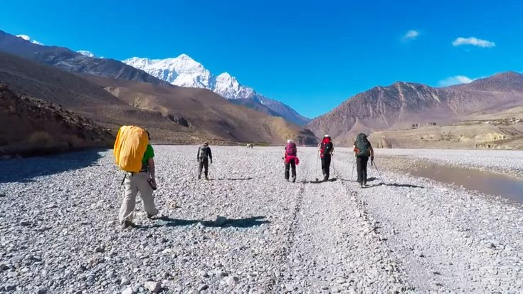
An early morning flight (typically 20-25 minutes) takes you from Pokhara to Jomsom, weaving through the world’s deepest gorge between Dhaulagiri (8167m) and Annapurna I (8091m). Flights are timed for early morning because winds pick up in the Kali Gandaki valley by late morning, often grounding afternoon flights. From Jomsom, you’ll begin trekking north along the windswept Kali Gandaki riverbed, a landscape that shifts dramatically from green Annapurna foothills to the arid, high-desert terrain characteristic of Mustang.
The 2-3 hour walk to Kagbeni is relatively flat and easy, following the river through small settlements. Kagbeni itself is a striking medieval village of narrow alleyways, whitewashed mud-brick houses, and an old fort, marking the gateway to Upper Mustang (which requires a separate restricted-area permit if you wish to continue north).
From Kagbeni, the trail climbs steadily out of the river valley toward Muktinath, gaining roughly 960 meters over 4-5 hours. The path passes through Jharkot, a well-preserved traditional village with an old fort and monastery, before reaching Muktinath, one of the most sacred pilgrimage sites for both Hindus and Buddhists.
The temple complex features 108 water spouts shaped like bull heads that pilgrims believe cleanse sins, along with an eternal flame fueled by natural gas that burns alongside a natural spring, considered a rare and holy phenomenon. The views from here stretch across the barren Mustang landscape toward the Thorong La pass, and it’s common to spend the afternoon exploring the temple grounds and the surrounding Buddhist gompas.
Retracing your steps partway down the valley, the trail today descends back through Jomsom and continues south to Marpha, a 5-6 hour walk. Marpha is often called the cleanest village in Nepal and is famous for its apple orchards, distilleries producing apple brandy and cider, and tightly packed stone houses with flat roofs stacked with firewood, a style suited to the region’s strong winds and low rainfall.
The village’s narrow, flagstone-paved lanes and whitewashed walls give it a distinct character compared to the villages further north, and it’s a good place to sample local apple products and visit the Marpha Monastery on the hillside above town.
The trail continues south along the Kali Gandaki, and the landscape begins transforming again, from Mustang’s high desert back into pine and fir forest as you drop in elevation. This 5-6 hour stretch passes through villages like Tukuche, once an important trading post on the salt route between Tibet and India, and Kalopani, known for close-up views of Dhaulagiri and Annapurna. Lete itself sits in a forested area and offers a quieter, greener contrast to the stark terrain further up the valley.
Today involves a significant descent, roughly 1300 meters over 6-7 hours, following the Kali Gandaki gorge as it deepens and the vegetation grows lusher with subtropical forest, rhododendron, and cascading waterfalls. Tatopani, meaning “hot water” in Nepali, is well-earned relief for tired legs, as the village is known for its natural hot springs on the riverbank, a welcome place to soak sore muscles after over a week of trekking.
From Tatopani, you’ll typically drive to Pokhara (around 4-5 hours along a rougher mountain road through Beni), then either fly or take a further overland journey on to Kathmandu, or drive the full distance depending on road conditions and your preference. This is largely a transit day, giving you a chance to decompress and reflect on the trek before returning to the capital.
Depending on your flight schedule, you may have some free time for last-minute souvenir shopping in Thamel, picking up pashmina scarves, singing bowls, or handicrafts, before a representative transfers you to the airport for your departure flight.
Video
Lower Mustang Trek Packing List
Clothing
- Waterproof, breathable jacket and trousers
- Insulated down jacket
- Fleece or wool mid-layers
- Moisture-wicking base layers/thermals
- Trekking trousers and shorts
- Warm hat, sun hat, and gloves
- Trekking socks (wool blend) and liner socks
- Undergarments
Footwear
- Broken-in waterproof trekking boots
- Comfortable camp shoes/sandals
Gear
- Trekking poles
- Headlamp with spare batteries
- Sleeping bag (rated -10°C to -15°C)
- Daypack (30–40L) with rain cover
- Water bottles or hydration bladder
- Water purification tablets/UV steripen
- Sunglasses (UV protection, high-altitude rated)
Health & Personal Care
- Personal first-aid kit and personal medication
- Diamox (if prescribed, consult your doctor)
- Sunscreen (SPF 50+) and lip balm with sun protection
- Hand sanitizer and wet wipes
- Basic toiletries and quick-dry towel
Documents & Essentials
- Passport (6 months’ validity) + passport photos
- Travel insurance documents (with rescue evacuation cover)
- Printed permits (ACAP, TIMS) and trip vouchers
- Cash (USD and Nepali Rupees)
Miscellaneous
- Power bank and universal adapter
- Camera/phone with extra memory
- Snack bars / energy snacks
- Duffel bag for porter
- Earplugs and a book for teahouse evenings
Lower Mustang Trek – 10 Days FAQs
Yes. The region sees regular tourist traffic and has an established teahouse network along the route, which is part of why it’s often recommended for solo and first-time trekkers, including solo women.
No restricted-area permit is required. Lower Mustang only needs the standard ACAP and TIMS card, unlike Upper Mustang, which requires an additional $500 Restricted Area Permit.
Lower Mustang covers Jomsom, Kagbeni, Muktinath, and Marpha, and stays below 3,800 m with no special permit needed. Upper Mustang pushes further north past Kagbeni into the former walled kingdom of Lo Manthang, requires a costly restricted-area permit, and involves more remote, higher-altitude terrain.
Yes, largely. Because Mustang sits in the Annapurna range’s rain shadow, it receives far less monsoon rainfall than most of Nepal, making it one of the few Himalayan treks that stays feasible through summer, though some flight delays and landslide risk on connecting roads can still occur.
Yes. With gradual elevation gain, a max altitude under 3,800 m, and reliable teahouse infrastructure throughout, it’s widely regarded as a good entry-level Himalayan trek, suitable for trekkers with no prior high-altitude experience.
Most itineraries run 7–10 days depending on starting point and pace, though the trek can be shortened to 5–7 days for trekkers focused only on the Jomsom–Muktinath stretch.
It’s a rough, unpaved mountain road with steep switchbacks that typically takes 8–10 hours by jeep or bus, which is why most itineraries favor flying between Pokhara and Jomsom instead.
Generally yes, given the moderate grading, gradual ascent profile, and option to arrange vehicle support from Jomsom onward, making the route more flexible than many other Himalayan treks.
It’s a shared pilgrimage site for Hindus and Buddhists, known for its 108 water spouts and a natural flame that burns beside a spring, a combination considered unusual and sacred by both traditions.
Yes. It’s commonly linked with the Annapurna Circuit, since the trail overlaps around Jomsom and Tatopani, and shorter add-ons to Lubra Village or a day-hike toward Upper Mustang viewpoints are also common.
Reviews
No reviews found.