Api Himal Trek Guide (2026): Route, Itinerary, Cost, Difficulty & First-Hand Experience
Api Himal Base Camp Trek Guide (2026): Route, Itinerary, Cost, Difficulty & First-Hand Experience
Most things written about the Api Himal Base Camp Trek read the same way: “untouched wilderness,” “off the beaten path,” “raw and rugged.” All true. None of it tells you what the trek is actually like. I did this route in spring 2026, driving overland both ways from Kathmandu, and I want to write about it the way it deserves with the village nights, the permit paperwork, and the parts no brochure mentions.
There is also a reason to write about Api Himal right now rather than later. In 2026, Prime Minister Balen Shah’s government named Api Himal in Darchula alongside Ramaroshan in Achham and Badimalika in Bajura as a priority trekking route in its 100-day governance reform plan for Sudurpashchim Province. For a region that has long been overshadowed by Everest and Annapurna, that is a meaningful signal. Infrastructure, route management and government attention are finally catching up to what trekkers who have already been there already know: this is one of the most rewarding and least crowded trekking regions left in Nepal.
The Nepal Tourism Board continues to promote sustainable tourism across remote regions, including Sudurpashchim Province, and lists far-western routes among the destinations it is actively developing for international visitors.
Api Himal Base Camp Trek: Quick Facts
| Detail | Information |
| Trek region | Darchula District, Sudurpashchim Province, Far-West Nepal |
| Max elevation | 4,200m (Kalidhunga Lake); Base Camp at 3,861m |
| Trek duration | ~12 days overland from Kathmandu (~10 days if flying to Dhangadhi) |
| Trek difficulty | Moderate to challenging, no technical climbing required |
| Best seasons | Spring (March–May) and Autumn (September–November) |
| Permits required | Api Nampa Conservation Area Permit + TIMS Card |
| Accommodation | Local homestays and basic lodges/camping |
| Starting point | Makarigaad, via Darchula |
| Conservation area | Api Nampa Conservation Area (1,903 sq. km) |
Why Api Himal, and Why Now
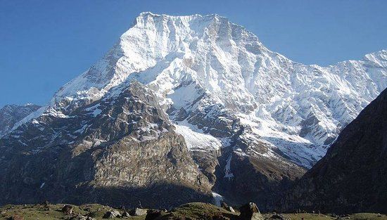
Mt. Api stands at 7,132 metres in the Api Nampa Conservation Area of Darchula district, the highest peak in Nepal’s Far-Western region. Unlike Everest Base Camp or Annapurna Circuit, where you share the trail with hundreds of trekkers a day, Api Himal sees a fraction of that traffic. On our 12 days, we passed more water buffalo than foreign trekkers.
That is changing, slowly and deliberately, as a government priority not just marketing language. The far-west has the mountains (Api at 7,132m, neighbouring Saipal at 7,031m), the conservation area infrastructure, and now political attention. For trekkers who want the Everest-in-the-1960s experience without leaving Nepal, this window will not stay open as quietly as it is now. You can browse our full range of
Nepal trekking and walking packages here to see how Api Himal compares with our more established routes.
Getting There: The Overland Route
 We chose to drive both ways rather than fly into Dhangadhi, mainly for cost and because we wanted to see the Mahakali Valley properly. It is long we split the Kathmandu to Dhangadhi leg into two driving days rather than attempting it in one push, which I would strongly recommend to anyone doing the same. The road past Bardiya National Park and across the Karnali Bridge is one of the better-looking drives in Nepal, but it is not a road you want to rush after dark.
If your schedule is tighter than ours, flying Kathmandu to Dhangadhi cuts roughly two days off the trip and most operators offer it as an option. We do not regret the overland route – it added real context to where Darchula sits relative to the rest of the country – but it is a decision to make deliberately, not by default.
The Trail: Villages Before Mountains
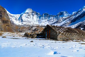 Everyone plans this trek around Api Base Camp and Kalidhunga Lake, and they should both are genuinely worth the effort. But if I am honest about what stayed with me afterward, it was not the high points. It was Ghusa Gaun and Siti Gaun, the homestay villages along the way.
Staying with a local family in Ghusa Gaun, sharing a meal cooked over a wood fire, and being offered tika before continuing the next morning that is not something you get on the more commercialised trails further east, where teahouses have become standardised stopovers rather than someone’s home. Siti Gaun’s traditional four-storey mud houses are still lived in exactly the way they look like they should be lived in. These villages belong to the Shauka and Raji communities, and the trek is as much a walk through their daily life as it is a walk toward a mountain.
This was, by a clear margin, the toughest and most memorable part of the trek for me – not the altitude, not the trail conditions, but adjusting to and being welcomed into a way of life this far removed from anything in Kathmandu.
Api Base Camp and Kalidhunga Lake
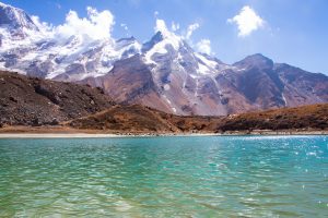 Api Base Camp sits at 3,861m, with a small temple site locally associated with Lord Shiva, who is believed to have meditated here after Kailash. It is a quiet, almost contemplative spot, and a sharp contrast to the energy of base camps in the Khumbu.
The genuine high point in both senses is Kalidhunga Lake at 4,200m, a short push beyond base camp. The lake is glacier-fed, ringed by peaks including Nampa and Hardeol, and it is where most of our group’s photos came from. Altitude sickness risk here is lower than on treks that push past 5,000m, but it is not negligible, and a proper acclimatisation day before the push to the lake is worth keeping in the itinerary rather than cutting it.
Suggested 12-Day Itinerary
This reflects the overland version of the route. If you fly into Dhangadhi, you can shorten the front and back end by roughly two days.
| Day | Route | Notes |
| 1 | Kathmandu → towards Dhangadhi (overland) | We split this into two driving days on the Mahendra Highway rather than one brutal 14-hour push |
| 2 | Dhangadhi → Gokuleshwor / Darchula | Follows the Mahakali Valley along the Nepal-India border; first close views of the far-west hills |
| 3 | Darchula → Makarigaad | Trailhead drive; permits checked at the Api Nampa Conservation Area office |
| 4 | Makarigaad → Naupata | Trek begins through terraced fields and lower forest |
| 5 | Naupata → Ghusa Gaun | First homestay night – this is where the trip really started for us |
| 6 | Ghusa Gaun → Siti Gaun | Traditional four-storey mud houses; locals offered tika before we continued |
| 7 | Siti Gaun → Dhauliodhar | Chameliya river valley, stone-stepped forest trail |
| 8 | Dhauliodhar → Api Base Camp (3,861m) | Long climbing day; a small temple site at base camp is locally tied to Lord Shiva |
| 9 | Api Base Camp → Kalidhunga Lake (4,200m) → back to Dhauliodhar | Highest point of the trek; the lake is the real reward, more than base camp itself |
| 10 | Dhauliodhar → Ghusa Gaun | Retracing the route, second night with the same host family |
| 11 | Ghusa Gaun → Makarigaad | Final trekking day back to the roadhead |
| 12 | Makarigaad → Darchula → towards Kathmandu (overland) | Return journey begins |
Food on the Trail: What You’ll Actually Eat
Food on the Api Himal Trek is a genuine mix, and that surprised us. In the homestay villages Ghusa Gaun and Siti Gaun especially – meals were proper local Far-West cooking: dal bhat with seasonal mountain greens, buckwheat and maize-based dishes that you do not see on the Everest or Annapurna menus, and milk tea made fresh each morning. Portions were generous and the hospitality made up for the lack of variety.
Closer to the trailhead towns and on a few rest days, we also had access to more familiar trail food noodles, eggs, basic Western-style breakfasts – which was a welcome change of pace before pushing back into the remote stretches. If you are used to the teahouse menus of the Annapurna Circuit, recalibrate your expectations: this is simpler, more seasonal, and far more dependent on what a particular village has on hand that week. Carrying some of your own energy bars or snacks for the high-altitude push to Kalidhunga Lake is a sensible backup, since options thin out considerably above Dhauliodhar.
Wildlife and Birds: What We Actually Saw
The Api Nampa Conservation Area is one of the richer wildlife corridors in Nepal’s far-west, and it showed. We spotted Danphe (Nepal’s national bird) and Munal pheasants moving through the upper forest and meadow sections – both unmistakable once you see the colouring against the green. Higher up, near the base camp approach, we had two separate sightings of blue sheep grazing on the exposed slopes, and a brief but clear look at a Himalayan tahr on a rocky outcrop above the trail.
The conservation area is also home to snow leopards, musk deer and Himalayan black bears, though sightings of these are rare and we did not see any ourselves – worth knowing so expectations stay realistic. What stood out more than any single sighting was how alive the whole route felt: the forest sections below Siti Gaun were thick with birdsong, and the alpine meadows near base camp had a density of wildflowers in spring that no photograph we took really captured.
Trail Conditions: What to Actually Expect Underfoot
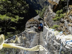 Route conditions varied more than any single trail description gives credit for. Through the lower villages Naupata, Ghusa Gaun, Siti Gaun – the trail is well-trodden, gently graded, and easy to follow, mostly stone-stepped paths through forest and farmland. It is the stretch from Dhauliodhar up to Api Base Camp where the trek earns its “moderate to challenging” rating: steeper, less defined in places, and exposed to weather changes that can move in quickly at altitude.
None of it is technical no ropes, no scrambling but the combination of altitude, distance and underfoot conditions on that final push means fitness matters more than trekking experience here. We were glad to have built in an acclimatisation day before the push to Kalidhunga Lake rather than rushing it.
Challenges We Didn’t See Coming
- The overland drive itself was more physically tiring than several trekking days combined budget real recovery time before starting the trail.
- Limited facilities in the homestay stretch: no hot showers, no laundry, and very little phone signal for days at a time. Mentally preparing for that mattered as much as physical training.
- Weather above Dhauliodhar changed faster than forecasts suggested we had clear skies turn to cloud cover within an hour on the approach to base camp.
- Sourcing reliable, up-to-date information before the trip was genuinely difficult, since so little has been written about this route compared to Nepal’s more popular treks – part of why we are writing this.
The Highlight: Reaching Api Base Camp
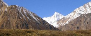 Of everything on this trek the villages, the wildlife, the lake – the single moment that stayed with us most was standing at Api Base Camp itself, 3,861m, with the full Api massif rising directly ahead and almost no one else around. After days of build-up through forest and farmland and homestays, the sudden scale of the mountain at close range was disorienting in the best way. The small temple site there, with its local association to Lord Shiva, added a quiet, almost meditative weight to the moment that we did not expect going in.
Permits and Practical Information
Permits and protected-area access for Api Himal are administered through the Api Nampa Conservation Area authority, under the oversight of Nepal’s Department of National Parks and Wildlife Conservation (DNPWC). Checking current permit fees and any conservation area regulations directly with these official sources before travel is recommended, since requirements can be updated.
| Permit / Document | Where Issued | Typical Purpose |
| Api Nampa Conservation Area Permit | Conservation area office, Darchula | Required entry permit for the protected area |
| TIMS Card | Registered trekking operator or TAAN/NTB | Trekker identification and safety tracking |
| Local government registration | Darchula district office (via operator) | Some remote sections require local trail registration |
- Best seasons: Spring (March–May) for wildflowers and milder trails, Autumn (September–November) for the clearest mountain views. Winter is not recommended at this altitude and remoteness.
- Trek difficulty: Moderate to challenging, mostly due to remoteness and trail length rather than technical terrain. No climbing skills required, but several months of cardio and strength preparation will make a real difference.
- Max altitude: 4,200m at Kalidhunga Lake low enough that altitude sickness risk is lower than on treks pushing past 5,000m, but proper acclimatisation still matters.
- Accommodation: A mix of homestays and basic camping/lodge facilities. This is not a teahouse trek in the Annapurna sense come prepared for simpler facilities, limited hot showers, and no laundry service.
- Connectivity: Limited to none for most of the trek. Plan for it, rather than fighting it.
Is the Api Himal Trek Right for You
This trek suits people who have done at least one moderate multi-day trek before and want something further off the beaten path than Everest, Annapurna or even Manaslu. It is not the right starting trek for a first-time visitor to Nepal, mainly because of the remoteness and the limited infrastructure if anything goes wrong. It is, however, exactly right for trekkers who keep saying they want “somewhere that hasn’t been ruined by tourism yet” because right now, that description is still accurate.
With the government’s renewed attention on Sudurpashchim’s trekking routes, that may not stay true indefinitely. There is a real argument for going in the next year or two, while the trail still feels the way it does today.
Frequently Asked Questions
How difficult is the Api Himal Base Camp Trek?
Moderate to challenging. The lower sections through villages like Naupata, Ghusa Gaun and Siti Gaun are gentle and well-trodden. The push from Dhauliodhar to Api Base Camp (3,861m) and on to Kalidhunga Lake (4,200m) is steeper and weather-exposed, though not technical.
What wildlife can you see on the Api Himal Base Camp Trek?
Danphe and Munal pheasants are commonly spotted in the forest and meadow sections. Blue sheep and Himalayan tahr are visible on the higher slopes near base camp. Snow leopards, musk deer and Himalayan black bears live in the Api Nampa Conservation Area but are rarely seen.
What is the best season for the Api Himal Base Camp Trek?
Spring (March–May) for wildflowers and milder conditions, Autumn (September–November) for the clearest mountain visibility. Winter is not recommended given the altitude and remoteness.
Do you need a guide for the Api Himal Base Camp Trek?
It is strongly recommended. Trail marking thins out considerably above Dhauliodhar, permits are processed through the Api Nampa Conservation Area office, and the homestay network in villages like Ghusa Gaun and Siti Gaun is far easier to access with a local guide or registered operator.
How long is the Api Himal Base Camp Trek?
Around 12 days door-to-door if travelling overland from Kathmandu, or roughly 2 days shorter if flying into Dhangadhi. Actual trekking days on the trail are closer to 7–8.
Related Treks Worth Comparing
If you are weighing Api Himal against Nepal’s more established routes, a few of our other guides may help:
- 10 Best Treks in Nepal for Every Budget – see where Api Himal sits cost- and difficulty-wise against EBC, Annapurna and Manaslu
- 13 Days Annapurna Circuit Trek – our most popular classic circuit, for comparison
- Paanch Pokhari Trek Guide – another offbeat, less-crowded alternative closer to Kathmandu
Also, Check Api Himal Base Camp Trek
Final Thoughts
The Api Himal Trek stands as one of Nepal’s most untouched and rewarding trekking experiences, offering breathtaking Himalayan scenery, rich local culture, and true wilderness far from the crowded trails. It is a perfect choice for adventurous trekkers seeking something unique and off the beaten path.
To dive deeper into planning, preparation, routes, and essential tips, don’t miss our detailed Api Himal Trek Complete Guide, designed to help you understand every aspect of this incredible journey.
Take the first step toward this remote Himalayan adventure and experience the raw beauty of far-west Nepal like never before.
Start your adventure today and experience one of Nepal’s most remote and rewarding trekking destinations.
Planning Your Trek with Guru Travels
Having done this route ourselves, we now build Api Himal Base Camp itineraries informed by what actually works on the ground – from realistic driving-day planning to which villages are worth a rest day, not just a passing meal. If you are considering the far-west for your next trek, reach out to our team and we can plan a route that matches your timeframe, season and fitness level.
Explore more of what we offer at Guru Travels Limited, Nepal’s first public limited travel company.